The Toulourenc River
 The Toulourenc is the principal tributary of the Ouveze, draining the north flank of the Mont Ventoux in an extraordinary mountainous landscape. The region was densely settled and deforested in the 19th century, but since then experienced reduced human pressure and reforestation, such that many (but not all) tributary streams have narrowed and incised in response to the reduced sediment load. We will visit streams displaying contrasting patterns of post-19th century adjustment. We will conduct facies mapping and surface sediment sampling, long profile and cross-section surveys, and habitat mapping techniques in the Toulourenc River.
The Ouvèze River
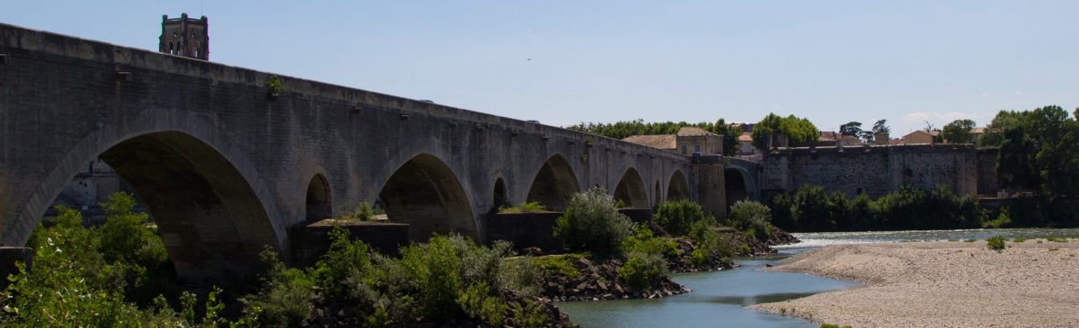
 The Ouvèze River drains the Baronnies region and the north slope of the Mont Ventoux in the preAlps of southeastern France. At Vaison-la-Romaine it has a drainage area of 1800 sq km, and transitions from mountains to alluvial plain, which it traverses for about 40 km to its confluence with the Rhône River at Orange. The drainage basin of the Ouvèze has a Mediterranean climate, with the highest peak flows generated by infrequent but intense convective rainstorms (typically Sept-Nov), characterized by very rapid rise in stage and little warning of impending high floods. Such an extreme event occurred on the Ouvèze in September 1992, resulting in 28 deaths in a campground along the river and extensive damage. Some of the bridges along the river washed out, with the exception of the Roman-era bridge at Vaison-la-Romaine, which was built at a bedrock narrows.
We will review the historical record of catchment and channel changes on the Ouveze, visit the Roman bridge and floodplain lands affected by the 1992 flood, examine the post-19th century riparian forest along the river, and examine areas of recent vineyard expansion. We will use the visit to the Ouvèze to demonstrate field techniques including mapping channel forms and habitats, facies maps/pebble counts, and vegetation surveys. Near Gigondas, we will visit a family property that has been producing wine since 110 AD (when it was settled by a retired Roman general), and examine wine cuves carved by the Romans and still in use today. We’ll consider implications of the long history of settlement in setting restoration goals for rivers, and as it is expressed in the fruits of this extraordinaryterroir.
Floodplain reconnection and habitat restoration on the old Rhône at Pont St Esprit
 Like other major rivers in the developed world, the Rhône has been profoundly altered by developments for hydroelectric production, navigation, flood control, aggregate mining, etc. What is exceptional about the Rhône is the ongoing, coordinated, basin-wide program of restoration, which includes projects to revitalize sections of natural river bypassed by canals for hydroelectric generation, restoration of former channels, re-introduction of coarse sediments, and reconnection of floodplains, both for habitat restoration and to increase flood conveyance. We visit a recent floodplain and secondary channel reconnection and restoration project on the old Rhône near Pont St Esprit. Go here for a description in French).
Post-shortcourse optional field trips near Lyon; selected field trips to be confirmed in May 2020

You must be logged in to post a comment.